Lavineyard Farms is an all organic, family-owned boutique lavender farm with an Italian vineyard. Nestled in the foothills of Shasta County, Lavineyard Farms and Ridgetop Cellars collaboratively present a unique blend of Sangiovese and Primitivo. The farm has the largest collection of lavender varieties.
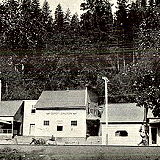
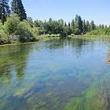
Whitmore is an unincorporated community in Shasta County, California. Its population was 311 as of the 2020 census. This region experiences hot and dry summers.
Wild Horse Sanctuary is located near Shingletown, California on 5,000 acres of lush lava rock-strewn mountain meadow and forest land. The preserve is dedicated to the protection and preservation of America's wild horses.
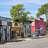
Shingletown is a census-designated place in Shasta County, California, United States. Its population is 2,442 as of the 2020 census, up from 2,283 from the 2010 census. Shingletown has a history of logging large timber, including pine, fir and cedar. It is also known as "The Gateway to Lassen".
TBS Ranch in Palo Cedro, CA is an idyllic wedding venue, meticulously designed to be your dream location for celebrating the cherished, once-in-a-lifetime moments with your family. The venue's unique and tasteful aesthetic, complemented by the dedicated services, is tailored to elevate the vision you have for your special day.
Palo Cedro is a census-designated place in Shasta County, California, United States. It is 8 miles (13 km) east of Redding. Its population is 2,931 as of the 2020 census, up from 1,269 from the 2010 census.
The nearly 400 acre Little Bear Creek Ranch quaintly sits in the foothills of Shasta county, in the heart of the historic Parkville community approx 16 miles southeast of Redding. The ranch consists of rolling hills, vast groves of oaks, pastures, and rangeland with stunning views of Mount Lassen and open fields.
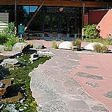
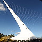
Turtle Bay Exploration Park is a popular attraction located in Redding, California. It is situated on the banks of the Sacramento River in Redding, Shasta County, California. It covers an area of approximately 300 acres (121 hectares) and offers a mix of indoor and outdoor attractions.
Shasta County is a county located in the northern part of California. It is part of the Sacramento Valley region and is bordered by the Cascade Range to the north and the Sierra Nevada Mountains to the east. The county seat of Shasta County is Redding, which is the largest city in the county and serves as its primary economic and cultural center. Its population was 182,155 in 2020.
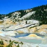
Lassen Volcanic National Park is a national park located in northeastern California. The park features a variety of volcanic features, including steaming vents, boiling mud pots, and hot springs, as well as volcanic peaks and alpine lakes.
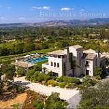
Bella Vista is a census-designated place located in Shasta County, Northern California. It is situated about 8 miles northeast of the city of Redding and is known for its rural and scenic surroundings. The city is a part of the Redding metropolitan area and is situated near the foothills of the Cascade Range. Its population was 3,641 in 2020, up from 2,781 in 2010.
Castella is a small unincorporated community located in Shasta County, Northern California, United States. It's situated near the base of Mount Shasta, a prominent and iconic volcano in the region. Castella is known for its scenic beauty, outdoor recreational opportunities, and its proximity to natural landmarks. Its population is 214 as of the 2020 census, down from 240 from the 2010 census.
Cottonwood is a small community located in Shasta County, Northern California, United States. It's situated south of Redding, the largest city in the area. Cottonwood is known for its rural and agricultural character, as well as its proximity to outdoor recreational opportunities. Its population is 6,268 as of the 2020 census, up from 3,316 from the 2010 census.
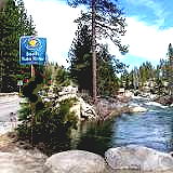
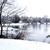
Fall River Mills is a small community located in Shasta County, Northern California. It's situated in the northeastern part of the state, surrounded by scenic landscapes and natural beauty. Fall River Mills is known for its outdoor recreational opportunities, especially related to fishing and water activities. Its population is 616 as of the 2020 census, up from 573 from the 2010 census.
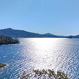
Big Bend is a small unincorporated community located in Shasta County, in the northern part of California, in the Shasta-Trinity National Forest area. It's known for its scenic beauty and outdoor recreational opportunities. It's nestled along the banks of the Pit River and near the Pit River Arm of Shasta Lake. Its population is 79 as of the 2020 census, down from 102 from the 2010 census.
Cassel is a small unincorporated community located in Shasta County, in the northeastern part of California, near the base of the Cascade Range and Mount Shasta. It's part of the Shasta-Trinity National Forest area. Its population is 207 as of the 2020 census.
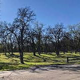
Centerville is an unincorporated community in Shasta County, California, United States. Centerville is 6.5 miles (10.5 km) southwest of Redding. In 2018, the community was evacuated due to the Carr Fire, which destroyed homes in the community. Its population was 2,095 in 2020.
Anderson is a city located in Shasta County, California. It situated in the northern part of California, in the Shasta Cascade region. It is located just south of Redding, the largest city in the area. The city is nestled between the Sacramento River and the foothills of the Cascade Range.
The Sundial Bridge is a prominent landmark located in Redding, California. The Sundial Bridge is situated in Turtle Bay Exploration Park in Redding, Shasta County, California. It spans across the Sacramento River, connecting the north and south sides of the park.
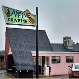
The Alpine Drive Inn is a classic drive-in restaurant located in Burney, California, United States. It has been a local favorite since it opened in 1978, serving classic American diner fare such as burgers, fries, and milkshakes.