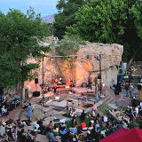
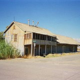
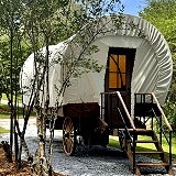
Mill Creek Station in Bishop, California, is a prominent historic site and transportation hub located in the Eastern Sierra region. It can serve as a historical landmark, a visitor center, or a community center, depending on conservation efforts and local initiatives.
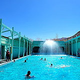
Keough's Hot Springs offers the stunning beauty and relaxation of a unique experience. It's the largest natural hot spring lake in the Eastern Sierra and features a cooling waterfall system cascading into a larger pool, as well as a hot spring soaking pool. Amenities include sun loungers, a snack bar, a picnic area, and a rock garden trail for relaxation.
Wilkerson is a small community located in Inyo County, California. It lies in the Owens Valley, between the Sierra Nevada and White Mountains. The community is situated at an elevation of approximately 1,341 meters (4,400 feet), enjoying a relatively mild climate compared to the lower desert regions. As of 2024, the population was approximately 594, with the most recent 2020 census recording 495 residents.
Homewood Canyon is a remote and sparsely populated area located in Inyo County, California, in the eastern part of the state. It is situated in the eastern Sierra Nevada region, not too far from the Nevada border. Homewood Canyon sits at an elevation of 3,074 feet (937 m). The 2010 United States census reported Homewood Canyon's population was 44.
Keeler is another small unincorporated community located in Inyo County, California. It lies on the eastern shore of the now largely dry Owens Lake. Approximately 3,600 feet (1,100 meters) above sea level. It is situated about 10 miles southeast of Lone Pine and 12 miles east of Olancha. The population was 71 people at the 2020 census, up from 66 at the 2010 census.
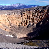
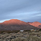
Ubehebe Crater is a prominent volcanic feature located in the northern section of Death Valley National Park, California. It is part of the Ubehebe Craters volcanic field, which includes several overlapping craters formed by explosive volcanic activity. The largest crater is about 800 m (0.5 mi) wide and 250 m (800 ft) deep.
Mesa is a census-designated place in Inyo County, California, United States. The population was 251 at the 2010 census, up from 214 at the 2000 census. Inyo County is known for its beautiful and varied landscapes, including parts of the Eastern Sierra Nevada, Death Valley National Park, and other natural attractions.
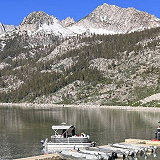
South Lake is an unincorporated community in the Kern River Valley, in Kern County, California. It is located 4.5 miles (7.2 km) west-southwest of Weldon, at an elevation of 2,887 feet (880 m). South Lake is located along the south shore of Lake Isabella.
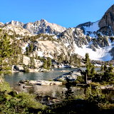
Treasure Lakes is a picturesque hiking destination located in the Eastern Sierra region of California, specifically within the Inyo National Forest. This area is renowned for its stunning alpine lakes, granite landscapes, and diverse recreational opportunities.
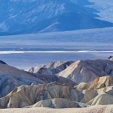
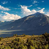
Dante's View is a prominent viewpoint located in Death Valley National Park, California, at an elevation of approximately 5,475 feet (1,669 meters) above sea level. It offers stunning panoramic views of the surrounding landscape, including the vast expanse of Death Valley below, which features both the lowest point in North America at Badwater Basin and Telescope Peak, the highest point in the park.
Great Falls Basin is a notable geographical area located within the larger Great Basin region of the western United States, primarily in California. This basin is characterized by its unique topography and ecological features.
Valley Wells is a census-designated place in Inyo County, California. The 2010 census reported that population was zero. Valley Wells is situated in the Mojave Desert, a vast arid region in southeastern California. It lies near the Nevada border and is accessible via Interstate 15, which is a major route connecting Southern California to Las Vegas.
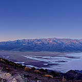
Death Valley is a desert valley in Eastern California, in the northern Mojave Desert, bordering the Great Basin Desert. In this below-sea-level basin, steady drought and record summer heat make Death Valley a land of extremes. Yet, each extreme has a striking contrast. Towering peaks are frosted with winter snow. Rare rainstorms bring vast fields of wildflowers. Lush oases harbor tiny fish and refuge for wildlife and humans.
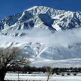
Round Valley is a census-designated place in Inyo County, California. Round Valley is located 7.5 miles (12 km) northeast of Mount Tom, at an elevation of 4692 feet (1430 m). The population was 482 at the 2020 census, up from 435 at the 2010 census.
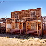
The Golden Cactus Ghost Town & Museum, located in Pearsonville, California, is an engaging destination that offers visitors a glimpse into the Old West. Visitors can explore various antiques and artifacts that highlight the region's history. Notable installations include a jail constructed from stacked lumber and a Can-Tin Cantina made from beer cans.
Pearsonville is a census-designated place in Inyo County, California. The population was 17 at the 2010 census, down from 27 at the 2000 census. Pearsonville is located in the eastern part of California, along U.S. Route 395, south of the town of Olancha and north of the city of Ridgecrest.
Dixon Lane-Meadow Creek is a census-designated place located in Fresno County, California, in the San Joaquin Valley region. It is east of the city of Fresno and is part of the larger Fresno metropolitan area. The population was 2,780 at the 2020 census, up from 2,645 at the 2010 census.
Bitterbrush is a popular campground in spring and fall as it is frequently below the snow line or just has minor amounts of snow. It has 30 campsites along the banks of Big Pine Creek. Bearproof food storage containers available in the campground. Free winter camping November-March.
Lone Pine Creek is a stream located in Lone Pine, California, a small town in the Owens Valley region. The creek originates from the Sierra Nevada mountains, specifically from the Mount Whitney area, which is the highest peak in the contiguous United States. It flows eastward through the town of Lone Pine and eventually merges into the Owens River.
Temple Crag is a mountain peak in the Palisades group of peaks of the Sierra Nevada with an elevation of 12,982 feet (3,957 m). The peak lies east of the Sierra Crest, between Mount Gayley and Mount Alice, straddling the drainage of the North and South Forks of Big Pine Creek.