
|
Olancha Peak California Last Updated: 10/22/2023 |
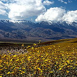
| Olancha Peak is a prominent mountain located in the Sierra Nevada mountain range of California, in Inyo County, California. It is approximately 50 miles south of Lone Pine and Independence and is easily visible from the Owens Valley. Olancha Peak has an elevation of 12,123 feet (3,695 meters) above sea level, making it one of the notable peaks in the Southern Sierra Nevada. | |
| - Hiking and Climbing: Olancha Peak is a popular destination for hikers and mountaineers. There are various hiking routes and trails leading to the summit, with the most common approach being from Sage Flat. While the mountain does not require technical climbing skills, hikers should be prepared for steep terrain, altitude, and variable weather conditions. - Views: Once you reach the summit of Olancha Peak, you are rewarded with breathtaking panoramic views of the surrounding Sierra Nevada mountains, the Owens Valley, and the Great Basin desert to the east. It's a beautiful vantage point for taking in the natural beauty of the region. - Wilderness: The peak is located within the Golden Trout Wilderness, which is known for its pristine alpine environments, clear lakes, and diverse flora and fauna. - Seasonal Considerations: Accessibility to Olancha Peak depends on the time of year due to snowfall and weather conditions. Typically, the best time for hiking is during the summer and early fall, from late June through September. Winter and early spring often see significant snowpack and more challenging conditions. - Permits: Depending on your specific hiking route and the time of year, you may need a wilderness permit, so it's essential to check with the appropriate agencies, such as the Inyo National Forest, for the latest information and regulations. Olancha Peak offers outdoor enthusiasts and hikers an opportunity to explore the stunning scenery of the Sierra Nevada, including the rugged and picturesque landscapes found in this region of California. | |
Wikipedia
Inyo County » Iny
Place » Outdoors
|
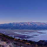
Dante's View Place » Outdoors Dante's View is a prominent viewpoint located in Death Valley National Park, California, at an elevation of approximately 5,475 feet (1,669 meters) above sea level. It offers stunning panoramic views of the surrounding landscape, including the vast expanse of Death Valley below, which features both the lowest point in North America at Badwater Basin and Telescope Peak, the highest point in the park. 213 views 💖 1 👍 0California |
|
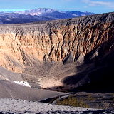
Ubehebe Crater Place » Outdoors Ubehebe Crater is a prominent volcanic feature located in the northern section of Death Valley National Park, California. It is part of the Ubehebe Craters volcanic field, which includes several overlapping craters formed by explosive volcanic activity. The largest crater is about 800 m (0.5 mi) wide and 250 m (800 ft) deep. 503 views 💖 1 👍 0Furnace Creek, California |

|
Father Crowley Overlook Place » Outdoors Father Crowley Vista Point was a favorite stopping place for travelers. Located near the western park boundary, this vista point offers a stunning view into Rainbow Canyon, a colorfully striped canyon created by ancient volcanic activity. A short ¼ mile (400 m) walk or drive on an unpaved road leads from the vista parking area to Padre Point, overlooking Panamint Valley. 142 views 💖 1 👍 0Parking lot, CA-190, Inyo, CA |
|
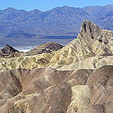
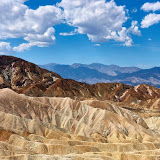
Zabriskie Point Place » Outdoors Zabriskie Point is a famous viewpoint in Death Valley National Park, California. Known for its dramatic and colorful landscape, it offers a stunning vista of the eroded and barren badlands of the Furnace Creek Formation. The landscape at Zabriskie Point has been shaped over millions of years through the erosion of sediments that were once part of an ancient lake bed. 364 views 💖 1 👍 0California |
|
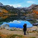
Lake Sabrina Place » Outdoors Lake Sabrina is a scenic alpine lake located in the Eastern Sierra region of Inyo National Forest, in the eastern part of Inyo County, in the eastern Sierra Nevada mountains of California. It is near the town of Bishop and is part of the Inyo National Forest. It is known for its stunning mountain scenery, clear waters, and recreational opportunities. 183 views 💖 1 👍 0Inyo County, California |
|
Inyo County Place » City Inyo County is a county located in the eastern part of California, United States. It is known for its spectacular natural beauty and is home to several national parks and wilderness areas, including Death Valley National Park, Mount Whitney, and the Ancient Bristlecone Pine Forest. In the 2020 census, the population was 19,016. The county seat is Independence. 449 views 💖 1 👍 0California |
|
Death Valley National Park Place » Outdoors Death Valley National Park is a vast desert wilderness located in eastern California, United States. It is one of the largest national parks in the country, covering over 3.4 million acres of rugged mountains, expansive sand dunes, and vast salt flats. 842 views 💖 1 👍 0California |
|
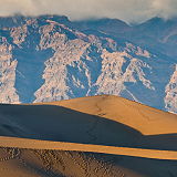
Mesquite Flat Sand Dunes Place » Outdoors The Mesquite Flat Sand Dunes are a popular attraction located in Death Valley National Park, California, United States. They are one of the largest sand dune complexes in the park, covering an area of over 14 square miles. 278 views 💖 1 👍 0Death Valley, CA 92328 |